Dda program to plot line segments, Computer Graphics

Assignment Help:

Use DDA algorithm to get the output of your program as shown in Figure

2008_DDA program to plot line segments.png

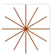
ANs: Use DDA( ) function to plot line segments that have end points on diametrically opposite points on the circumference of a circle.  Take these points on uniform distance.  For example, you may use the following function CirclePoints() to get line segment endpoints (x1 [i], y1[i])  and (x2[i], y2[i]), i=0,1,....5 and use the array 2 y ,2 x ,1y ,1x  as input to your dda() function. Call the DDA function six times as given in plot Lines code below. 

// Compute points on the circumference of a circle.

int Points(int r, int xc, int yc, int x1[6], int y1[6],int

x2[6], int y2[6])

{

 float pi = 3.1416;

 int i=0;

 for(float theta = 0; theta

 {

  x1[i] = xc + r*cos(theta);

  y1[i] =yc+r*sin(theta);

  x2[i] = xc + r*cos(pi+theta);

  y2[i] =yc+r*sin(pi+theta);

  i++;

 }

return x1[6], y1[6], x2[6],y2[6];

}

//Plot line segments using DDA algorithm

void plotLines()

{

 int xx1[6],yy1[6],xx2[6],yy2[6];

 Points(100, 200, 200, xx1, yy1, xx2,yy2);

 for(int i=0;i<=5;i++)

  dda(xx1[i], yy1[i], xx2[i], yy2[i]);

}  

Add the above code in your program for line segment generation using dda() function and call the function plotLines in your RenderScene() function.


Related Discussions:- Dda program to plot line segments

Gui and graphics, Newspapers exchange news by using news agencies (such as ...

Newspapers exchange news by using news agencies (such as Reuters and ITARTASS). A newspaper registers at a news agency and sends all its news to the agency. The news agency collect

Translation and shifting in spatial domain, Translation and shifting in Spa...

Translation and shifting in Spatial Domain A) The three images shown below were blurred using square masks of sizes n=23, 25, and 45, respectively. The vertical bars on the le

Explain vector data model with examples, Question 1 How does GIS differ fr...

Question 1 How does GIS differ from traditional Maps? Explain Question 2 Explain vector data model with examples Question 3 What is spatial analysis? explain

Input and hardcopy devices - 2d shape primitives, Input and Hardcopy Device...

Input and Hardcopy Devices  This section gives a brief introduction to the functioning of some well known input and hardcopy devices. Input devices include keyboard, mouse, sca

How does the z-buffer algorithm find out which surfaces, Illustration 1: H...

Illustration 1: How does the z-buffer algorithm find out which surfaces are hidden? Solution : Depth or Z-buffer algorithm employs a two buffer area each of two-dimensional ar

Important point about the de casteljeau algorithm, Important point about th...

Important point about the De casteljeau algorithm 1)      Bezier Curve: P (u) =    ................     (1) Here B n,i (u) = n c i u i (1 - u) n-i        ..

What is raster scan display, What is  Raster Scan Display A raster sca...

What is  Raster Scan Display A raster scan display device using CRT on the other hand directs the electron beam across the screen, one row at a time from top to bottom. In a ra

Interactive picture construction techniques, Explain the interactive pictur...

Explain the interactive picture construction techniques.    interactive picture- construction methods are commonly used in variety of applications, including design and painting pa

Bezier curves - modeling and rendering, Bezier Curves - Modeling and Render...

Bezier Curves - Modeling and Rendering Bezier curves are utilized in computer graphics to turn out curves which display reasonably smooth at all scales. Such spline approximat

Write Your Message!

Captcha
Free Assignment Quote

Assured A++ Grade

Get guaranteed satisfaction & time on delivery in every assignment order you paid with us! We ensure premium quality solution document along with free turntin report!

All rights reserved! Copyrights ©2019-2020 ExpertsMind IT Educational Pvt Ltd