Surface runoff travelling over ground surface to reach receiving water involves the following events:
i) Rainfall intensity exceeds soil's infiltration rate;
ii) Excess water moves on the ground due to the influence of slope and gravity;
iii) Flowing water accumulates in depression storage;
iv) Overflow of depressions form streams then to reach a receiving water such as river, lake, or ocean. Surface runoff can be increased by urbanization due to more impervious surfaces such as pavement and buildings that reduce the infiltration capacity of water into aquifer down through soil. Surface runoff is also affected by the characteristics of soil such as texture and water holding capacity. Runoff is measured in terms of the depth or volume of water.
Unit hydrograph is defined as direct runoff (also called effective precipitation) resulting from 1 unit (e.g. mm, cm, in) of excess rainfall generated uniformly over a drainage area at a constant rate for an effective duration. A unit hydrograph is usually described with respect to a specified duration of rainfall (e.g., 1 hr unit hydrograph). Generally, the duration of runoff is always greater than that of rainfall. Derivation of a unit hydrograph from laboratory is described as blow:
- Generate excess rainfall (e.g. by running the rainfall generator at the highest setting for 15 minutes);
- Get the volume of runoff over time (e.g. approximately 20 min);
- Get the total volume of direct runoff;
- Get direct runoff depth;
- Develop a unit hydrograph. Application of unit hydrograph is based on the following assumptions:
- Hydrographs developed from a unit hydrograph has a constant time base and shape.
- The runoff rates at a given point on the stream for the same duration of excess rainfall are proportional to the respective depths of excess rainfall.
- A hydrograph which results from a series of excess rainfall pulses can be developed from a series of overlapping unit hydrograph which are resulting from a single increment of excess rainfall of a specified duration.
- Implicit in deriving the unit hydrograph is the assumption that rainfall is distributed in the same temporal and spatial pattern for all storms.
Infiltration
Infiltration is the process by which water on the ground surface enters the soil. It is governed by two forces: gravity and capillary action. While smaller pores offer greater resistance to gravity, very small pores pull water through capillary action in addition to and even against the force of gravity. Once water has infiltrated the soil, it remains in the soil, percolates down to the ground water table, or becomes part of the subsurface runoff process. The velocity or speed of infiltration is called infiltration rate, which decreases as the soil becomes saturated. It is affected by the condition of the soil surface, vegetative cover, and soil properties such as porosity, hydraulic conductivity and moisture content. For example, coarse- grained sandy soils have large spaces between each grain and allow water to infiltrate quickly. Vegetation creates more porous soils by both protecting the soil from pounding rainfall, which can close natural gaps between soil particles, and loosening soil through root action. The maximum infiltration rate in a given condition is the infiltration capacity. If precipitation rate is less than infiltration capacity, all of the water will enter the soil. If the precipitation rate exceeds the infiltration capacity, ponding begins and is followed by runoff over the ground surface, once depression storage is filled. This runoff is called Horton overland flow. Infiltration rate is usually measured by the depth (in mm) of the water layer that can enter the soil in one hour. The most common method to measure the infiltration rate is by a field test using a cylinder or ring infiltrometer.
Objective
1) To understand the concepts of runoff and its rate, infiltration and its rate, infiltration capacity, and water budget.
2) To determine the total direct runoff formed from a 15-minute simulative rainfall and to develop 15-minute and 30-minute unit hydrographs based on the experiment.
3) To determine the total infiltration from the 15-minute simulative rainfall and to determine the infiltration rate.
Equipment
One rainfall simulator, a soil pan with topsoil, one pan used for collecting infiltrated water, two graduated cylinders used to measure the water from runoff and two graduated cylinders for infiltration. The experiment setup is shown in the following figure.
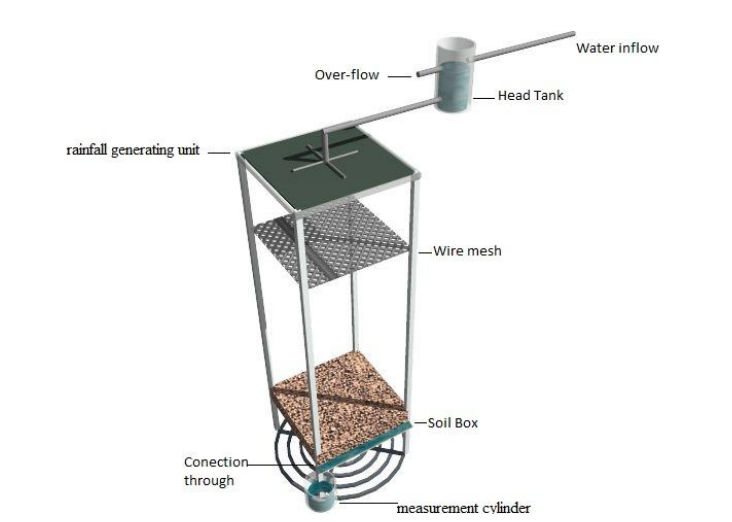
Figure: Experiment setup for measuring surface runoff
Procedure
1) Mount the soil pan under the rainfall generator (technician).
2) Mount the collection pan for infiltrated water under the soil pan (technician).
3) Generate rainfall for duration of 15 minutes following the procedures of Lab 1 for the highest constant head in the rainfall generating unit.
4) Measure and record the volume of water collected in the graduated cylinder for each 1 minute interval for 20 minutes for runoff and infiltration waters, even after the rain has stopped, beginning with the start of generated rainfall.
5) Determine the gross rainfall depth (using water budget equation and state your assumption) and direct runoff depth. Provide table and sample calculation.
Discussion
1) Plot the rainfall and measured direct runoff hydrograph.
2) Develop 15-minute and 30-minute unit hydrographs. Provide table and sample calculations.
3) Determine the infiltration and infiltration rate. Provide all necessary tables and sample calculations.
4) What are the most obvious differences between the derived unit hydrograph and one that you might expect to observe in a river?
5) Plot the following graphs:
a. Cumulative runoff vs. time
b. Cumulative infiltration vs. time, and
c. Infiltration rate vs. cumulative time.
d. Rainfall intensity vs. Time
6) How to determine the time which is taken to infiltrate a certain amount of water by using the graphs established in #5 above?