Reference no: EM132302927
Numerical Analysis - Numerical Simulation Project:
Use GeoStudio to numerically simulate the deformations and stability of a road constructed on the clay foundation. The foundation consists of 2.5 m desiccated and over-consolidated clay (at the top) and 7.5 m slightly over-consolidated soft clay stratum. The clay stratum is on top of the coarse sand and gravel with a high hydraulic conductivity so that the static pressure head at the top of gravel is 8.5 m. water table is at a depth of 1.5 m
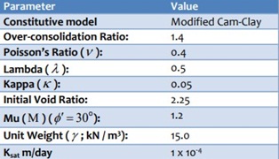
It is assumed that the pore-water pressure in the underlying granular material will not change due to the road construction. Also, assume that both the upper crust and the underlying clay are simplified to be homogeneous isotropic soil layers. Consider the following assumption along with Modified Cam-Clay (MCC) constitutive model in SIGMA/W for the soft clay.
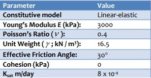
The volumetric water content function is not used for saturated conditions but is nonetheless required. Therefore, consider a volumetric water content of 0.3. In addition, assume the following for the desiccated clay crust.
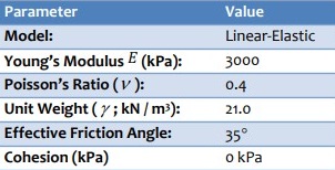
The road is an unsealed road with width and height of 14m and 1.8m, respectively. The material used for the road construction over a period of six days are coarse and sand gravel. There is no embankment for the road. All the relevant road material properties are listed in table below:
Note: Make reasonable assumptions if needed and state your assumptions clearly in your report.
Task:
Prepare a report with the following components:
a) Model Geometry (Max. 1-page image)
b) Model Materials (Max. 1-page text)
c) Boundary conditions and analysis type (Max. 2-page text/graph/image)
d) Discuss the changes in settlements, pore-water pressures and horizontal deflections at the depth of 10 m over next five years after construction. You need to include the graphs of excess pore-water pressure (during the road construction and long- term monitoring), long term settlement of the original ground surface, horizontal deflections (during the road construction and long- term monitoring).
The report must be submitted in the current MS Word file including the answers to the above questions. You should also upload your Geostudio into a Google drive and add the link to the report.