Spatial Data :-
Spatial data is the data or information that identifies the geographic location of features and boundaries on Earth, such as natured or constructed features Oceans, and more. It is also known as Geospatial Data or Geographic Information.
Layers of Spatial Data :-
Ø Communication Networks
Ø Land and Water transaction
Ø Land use
Ø Farm Holdings
Ø Ownership
Ø Soil Properties
Ø Water Flow
The process of examining the locations, attributes, and relationship of features in Spatial Data through overlay and other analytical techniques in order to address a question or gain useful knowledge is known as Spatial Analysis. Spatial Analysis extracts or creates new information from Spatial Data.
Spatial Data is usually stored as coordinates and topology and is data that can be mapped. Spatial Data is often accessed, manipulated or analyzed through Geographic Information System (GIS).
It refers to all type of data objects or elements that are present in a geographical space or horizon. It enables the global finding and locating of individuals or devices anywhere in the world.
A spatial data infrastructure (SDI) is a data infrastructure implementing a framework of geographic data, metadata, users and tools that are interactively connected in order to use spatial data in an efficient and flexible way.
Geographic Data :-
Geographic data can be used to determine a variety of characteristics of a population. Information gleaned from research using geographic data enables to compare basic details such as, economic status, average age, and ethnic diversity in different areas of the country.
Metadata:-
Metadata is information about data. Metadata summarizes basic information about data, which can make finding and working with particular instances of data easier. Similar to a library catalog record, metadata records document that who, what, when, where, how, and why of a data resource. Geospatial metadata describes maps, Geographic Information Systems (GIS) files, imagery, and other location-based data resources.
Users:-
Users are those who use Spatial Data directly or indirectly. It uses different tools to interact with Spatial Data.
Tools:-
Geographic Information Systems (GIS) :-
Geographic information systems (GIS) are systems for input, storage, manipulation, summarizing, editing, querying and visualizing geographic information.
Surveying :-
Surveying is the science of accurate measurement of natural and humanmade features on the Earth. Surveyors calculate the precise position of points, distances and angles through geometry.
Remote Sensing :-
Remote sensing is the use of satellites orbiting the Earth to capture information of the surface and atmosphere. Through the use of remote sensing, applying specific calculations to images can help spatial information analyst identify and classify features on a landscape such as changes in snowmelt.
Maps :-
Maps are mathematical representations of Earth and the Earth's surface. They can be used for geospatial data storage, spatial exploratory functions and as an analytical tool. Maps are a medium for visual communication of geospatial information relationships and depict human perception of the world. They can be used as spatial decision-making tools.
The purpose of a map is to reduce the complexity of the real world to communicate a specific idea. A map should be quickly and easily interpreted by the viewer.
Cartography
Cartography:-
Cartography is the design, construction and evaluation of maps. When designed well, maps can be powerful communication tools.
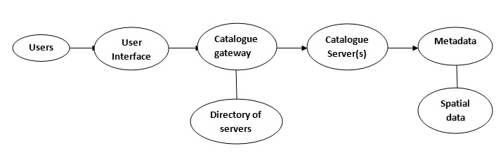
A SDI should enable the discovery and delivery of spatial data from a data repository, via a spatial service provider, to a user. It is desirable that the data provider is able to update spatial data stored in a repository.
Hence, the basic software components of an SDI are
Software client - to display, query, and analyse spatial data (this could be a browser or a desktop GIS).
Catalogue service - for the discovery, browsing, and querying of metadata or spatial services, spatial datasets and other resources.
Spatial data service - allowing the delivery of the data via the Internet.
Processing services - such as datum and projection transformations.
Spatial data repository - to store data, e.g., a spatial database.
GIS software (client or desktop) - to create and update spatial data.
ways to use GIS in Retail and Marketing:-
1. Macro Market Overview and Network Distribution:-
With GIS's help, channel managers have a quicker way to find hot new territories. In addition, understanding competitors' locations with GIS can also help in finding new areas for expansion.
2. Site Selection for New Branches/Facilities:-
GIS is a powerful spatial statistical and location management tool, which means it's good in dealing with comprehensive data such as interaction between demographic census and household purchasing behavior.
3. Target Market Campaign Enhancement:-
Some retailers need deliver localized advertising, and banks need to establish credit card applications in kiosks. Using GIS with rich points of interest, campaigns can be assessed as to whether or not they meet certain geographic and demographic criteria and can be stored according to the corresponding potential.
4. Performance Management and Evaluation:-
Evaluating a branch simply by checking its revenue is not the most effective solution, because finance point of view might miss some impacts that could not showing on the number. GIS could help by applying a model to estimate market share, capture the amount of households and the impact of competitors and cannibalization.
5. Merger and Acquisition Evaluation:-
By analyzing the location patterns of acquisition candidates, foreign banks can determine the best geographic coverage in relation to its branch networks. Foreign banks in most countries are suffering from some sort of license issues; therefore, it may be ideal that some local bank branches are distributed through similar optimization blue prints. GIS can help decide which candidates are the best buy and simulate grown up assessments after mergers.
Spatial Data may be classified as scalar or vector data. Each provides distinct information pertaining to Geographical or Spatial location.
It is a data infrastructure implementing a framework of Geographic data, Metadata, users and tools that are interactively connected in order to use Spatial Data in an efficient & flexible way.
Due to size, cost, number of interactions; an SDI is usually government related
Examples:-
* National Spatial Data Infrastructure (NSDI) in the United States.
* INSPIRE is a European commission.
* United Nations Spatial Data Infrastructure (UNSDI).