Reference no: EM131127617
LAB MODULE: AIR PRESSURE AND WIND
Note: Please refer to the GETTING STARTED lab module to learn how to maneuver through and answer the lab questions using the Google Earth) component.
KEY TERMS
You should recognize and understand these terms:
|
Atmospheric pressure
|
High pressure system
|
Pressure gradient force
|
|
Barometric pressure
|
Isobar
|
Pressure units (mmHg, inHg, mbar, hPa, kPa)
|
|
Beaufort wind scale
|
Katabatic winds
|
Solar radiation
|
|
Coriolis effect
|
Land-sea breeze
|
Wind
|
|
Frictional force
|
Low pressure system
|
Wind farms (wind arrays)
|
|
Gravity
|
Monsoon
|
Wind turbines
|
LAB MODULE LEARNING OBJECTIVES
After successfully completing this module, you should be able to:
? Recognize atmospheric circulation at local, regional and global scales
? Define and identify isobars on a map
? Distinguish wind movement and weather conditions between high and low pressure systems
? Identify the roles of gravity, pressure gradient, Coriolis and frictional forces on wind movement and wind patterns
? Convert miles per hour to knots using the Beaufort wind scale
? Recognize katabatic wind patterns
? Explain daily (day and night)l land-sea breeze wind patterns
? Provide examples of human uses of wind
In this lab module you learn about some fundamental principles of atmospheric pressure, wind processes and patterns, and global air circulation
INTRODUCTION
In this lab module you learn about some fundamental principles of atmospheric pressure, wind processes and patterns, and global air circulation. Topics covered include the factors that influence air pressure, high and low pressure systems, the direction of airflow, Coriolis force, frictional forces, atmospheric circulation, local wind systems, and wind energy. In doing so, you will recognize and appreciate the roles of the Sun, the Earth's atmosphere and surface of the Earth as they influence the movement of air at local to global scales.
The module starts with four opening topics, or vignettes, which are found in the accompanying Google Earth file. These vignettes introduce basic concepts and tools on which geographers rely. Some of the vignettes have animations, videos, or short articles that will provide another perspective or visual explanation for the topic at hand. After reading the vignette and associated links, answer the following questions. Please note that some links may take a while to upload based on your internet speed.
Expand the INTRODUCTION folder and then double-click and select Topic 1: Atmospheric Circulation.
Read Topic 1: Atmospheric Circulation.
Question 1: What are the three geographic scales of air movement and atmospheric circulation?
A. Global, National, Regional
B. National, Regional, Local
C. Global, National, Local
D. Global, Regional, Local
Read Topic 2: Weighing in on Atmospheric Pressure.
Question 2: Does an increase in elevation usually mean an increase or decrease in pressure?
A. A decrease
B. An increase
C. Elevation does not affect atmospheric pressure
D. It depends on the humidity levels
Question 3: Would Mt. Everest have a higher or lower atmospheric pressure than a location at sea level?
A. A higher atmospheric pressure
B. A lower atmospheric pressure
C. Elevation does not affect atmospheric pressure
D. It depends on the humidity levels
Read Topic 3: The Highs and Lows of Weather.
Question 4: Is the air sinking (descending) or rising (ascending) in the picture?
A. The air is sinking
B. The air is rising
C. The air is stationary
D. Unable to discern from information provided Read Topic 4: Human Interaction.
Question 5: How does data from wind turbines help weather forecasts?
A. They collect data at elevations where weather data are not routinely collected, which could improve forecasts
B. Wind speed data are used in the decision to turn on or off the turbines
C. Electricity generated from the turbines is used to power forecasting models
D. They don't. Turbines depend on weather forecasts Collapse and uncheck the INTRODUCTION folder.
GLOBAL PERSPECTIVE
Wind power is a form of solar power. Solar radiation (sunlight) heats up the surface of the Earth, but does so unevenly. This is because surfaces on Earth absorb, retain, and release heat at different rates. The uneven heating of the Earth's surface results in the formation of unequal pressures in the atmosphere; namely, high pressures and low pressures. As air pressure moves from high pressure areas to low pressure areas, wind forms. We can harness the power of wind near the Earth's surface with wind turbines, and convert the kinetic energy of wind into electricity (measured by kilowatts, kW, or megawatts, MW) for our homes and businesses. Note that all the wind speeds have been rounded to the nearest mile per hour. Remember to include your unit of miles per hour.
Expand the GLOBAL PERSPECTIVE folder. Double-click and select Wind Farm A.
Question 6: In which country is this wind farm?
A. Brazil
B. Chile
C. Argentina
D. Educador
Question 7: What is the average wind speed?
A. 13 mph
B. 23 mph
C. 33 mph
D. 43 mph
Double-click and select Wind Farm B.
Question 8: In which country is this wind farm?
A. Switzerland
B. Austria
C. Czech Republic
D. Vienna
Question 9: What is the average wind speed?
A. 12 mph
B. 22 mph
C. 32 mph
D. 42 mph
Double-click and select Wind Farm C.
Question 10: In which country is this wind farm?
A. Scotland
B. Northern Ireland
C. Wales
D. England
Question 11: What is the average wind speed?
A. 12 mph
B. 22 mph
C. 32 mph
D. 42 mph
Double-click and select Wind Farm D.
Question 12: In which part (northern, eastern, western, southern) of what country is this wind farm?
A. Northern
B. Eastern
C. Western
D. Southern
Question 13 What is the average wind speed?
A. 33 feet/sec
B. 33 km/h
C. 33 mph
D. 33 m/s
Double-click and select Area of Wind Farm. This shows the entire area of Wind Farm D.
Double-click and select Beaufort Wind Scale.
This wind scale is used to visually estimate wind. It was first introduced in 1805 by Sir Francis Beaufort, a British admiral and hydrographer to the Royal Navy. The Beaufort wind scale was then standardized in 1955 by the US National Weather Service.
Question 14: Based on the Beaufort Wind Scale, what would be the wind speed in knots for Wind Farm C? (Hint: 1 knot is 1.15 mph. To convert, take the wind speed for Wind Farm C and divide by 1.15 to determine the knots)
A. 19 knots
B. 23 knots
C. 29 knots
D. 15 knots
Question 15: Based on the Beaufort Wind Scale, what is the World Meteriological Organization's (WMO) wind classification for the average wind speed at Wind Farm C?
A. Light Air
B. Light Breeze
C. Gentle Breeze
D. Fresh Breeze
Collapse and uncheck the GLOBAL PERSPECTIVE folder.
FORCES OF WIND
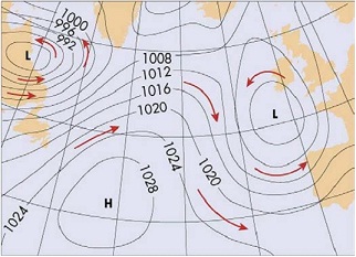
Isobars (iso = equal, bar = pressure) can provide us information about the speed and direction of wind. Isobars are plain, curved lines on a map that indicate areas of equal air pressure. Where lines are closer, the winds are stronger and therefore have more speed.
Several forces impact the speed and direction of wind. Gravity is arguably the most important - without gravity we would not have air pressure, and therefore, no wind. The pressure gradient force is also important - because of the tendency for air to move from areas of higher pressure (more dense air) to areas of low pressure (less dense air). However, wind at the surface does not flow across pressure gradients - that is, directly from high pressure systems to low pressure systems.
Figure 6.1: Atmospheric pressure map (Arbogast, 2nd Ed.)
This is due to the Coriolis effect (that is, the Earth spinning) deflecting wind from a straight path, as well as the frictional force reducing wind speed at the surface of the Earth.
Expand the FORCES OF WIND folder.
Select Pressure Gradient, Coriolis and Friction. In the pop-up window, click Pressure Gradient, Coriolis and Friction to view the animation (which opens in your browser). Within the animation, begin with Pressure Gradient and view both the chart and the details for all three physical forces.
Question 16: Pressure Gradient - what is the direction of air flow between high and low pressure systems?
a. Rotary motion, or twist, between high and low pressures
b. Movement at right angles between high and low pressures
c. Spiral into high pressure areas and out of low pressure areas
d. Spiral out of high pressure areas and into low pressure areas
Question 17: How do winds flow with pressure gradient?
a. Spiral out from isobars (between parallel and perpendicular)
b. Perpendicular (at right angles) to the isobars
c. Parallel to the isobars
d. None of these
Question 18: Pressure Gradient and Coriolis Forces - what is the direction of air flow between high and low pressure systems?
a. Rotary motion, or twist, between high and low pressures
b. Movement at right angles between high and low pressures
c. Spiral into high pressure areas and out of low pressure areas
d. Spiral out of high pressure areas and into low pressure areas
Question 19: Due to the Coriolis Effect, what hemisphere is shown in Figure 6.1?
A. Northern Hemisphere
B. Eastern Hemisphere
C. Western Hemisphere
D. Southern Hemisphere
Question 20: Pressure Gradient, Coriolis, and Friction Forces - what is the direction of air flow between high and low pressure systems?
a. Rotary motion, or twist, between high and low pressures
b. Movement at right angles between high and low pressures
c. Spiral into high pressure areas and out of low pressure areas
d. Spiral out of high pressure areas and into low pressure areas
Question 21: Considering all three forces, what hemisphere are you in when the wind is moving counterclockwise around lows (cyclonic) and clockwise around highs (anticyclonic)?
A. Northern
B. Eastern
C. Western
D. Southern
Select Coriolis Effect. In the pop-up window, click Coriolis Effect to view the animation (which opens in your browser).
Question 22: Due to the Coriolis force, what is the deflection from a straight path in the Northern hemisphere?
A. To the right
B. Straight ahead
C. To the left
D. There is no deflection
Collapse and uncheck the FORCES OF WIND folder.
GLOBAL CIRCULATION
Low pressures and high pressures can be examined at the global scale. For example, the warm, moist air at the equator rises and creates a low pressure, while the colder and denser air at the poles sinks and creates a high pressure. However, when these pressure systems are combined with the rotation of the Earth, the complexity of Earth's atmospheric circulation system is evident, with notable patterns and systems found at different latitudes, and at different elevations in the atmosphere. Overall, the global circulation system is important for the distribution of thermal energy (heat), water (precipitation), air masses, and wind.
Expand the GLOBAL CIRCULATION folder.
Double-click and select Global Model. Within the animation, identify the location of the Hadley cells, Ferrel cells, and Polar cells.
Question 23: Where the Ferrel cells migrate, do we find tradewinds, westerlies, or polar easterlies?
A. Tradewinds
B. Westerlies
C. Polar easterlies
D. None of the above
Question 24: Where the Hadley cells migrate, do we find tradewinds, westerlies, or polar easterlies?
A. Tradewinds
B. Westerlies
C. Polar easterlies
D. None of the above
Question 25: What is the general direction of deflection for the southeast tradewinds, westerlies and Polar easterlies in the southern hemisphere?
A. To the right
B. Straight ahead
C. To the left
D. There is no deflection
Question 26: Where is the ITCZ, or Intertropical convergence zone, more or less found?
A. Along the tropic of Cancer
B. Along the Tropic of Capricorn
C. Along the equator
D. At the poles
Double-click and select Cloud Fraction in January. To close the citation, click the X in the top right corner of the window.
Indirectly, clouds can show us where we can find high pressure and low pressure areas. Where we find significant cloud cover, low pressures exist due to the convergence and ascension of warm, moist air that cools, condenses and forms clouds.
This map shows the average global cloud cover for the month of January. The legend at the top shows the proportion of cloud cover, which ranges from no cloud cover at 0.0 (dark blue) to complete cloud cover at 1.0 (white).
Double-click and select Cloud Fraction in July. To close the citation, click the X in the top right corner of the window.
This map layer now shows the average cloud cover for the month of July. As you may notice, some areas with cloud cover maintain cloud cover, and some areas without cloud cover maintain cloudless skies. However, in some areas, cloudless skies are now cloudy and vice versa.
You will look at both January and July layers to answer the following questions. (Hint: If you need to locate the following places on Google Earth, type in the name of the country or area in the Search navigation bar and click Search.)
Question 27: Look at the cloud cover over Africa. In which cardinal direction (North, West, East, South) does the cloud cover move from January to July?
A. North
B. East
C. West
D. South
Question 28: In India, when is it the monsoon season (of seasonal cloud cover and precipitation)?
A. January
B. April
C. July
D. October
Question 29: What do these two locations tell us about the migration of low pressure systems/the ITCZ near the equator?
A. Low pressure systems migrate northward throughout the year
B. Low pressure systems are stationary
C. Low pressure systems migrate with the sub-solar point
D. Low pressure systems migrate counter to the sub-solar point Collapse and uncheck the GLOBAL CIRCULATION folder.
REGIONAL PRESSURE SYSTEMS
Alternating high and low pressures systems dominate the midlatitudes. Due to the global atmospheric circulation system, these high and low pressure systems generally migrate from west to east. The center of low pressure systems is denoted by an "L" while the center of high pressure systems is demarcated by an "H".
Associated wind patterns, designated by the isobars, indicate stronger and faster winds when the lines are closer together.
Expand the REGIONAL PRESSURE SYSTEMS folder. Double-click and select Isobars.
Select Location E and Location F. Zoom in so you can see both Location E and Location F.
Question 30: Does Location E have airflow that descends, diverges, ascends or converges?
A. Descends and diverges
B. Ascends and converges
C. Descends and converges
D. Ascends and diverges
Question 31: What is the weather like, in terms of cloud cover and potential precipitation at Location E?
A. Sunny and little chance of rain
B. Cloudy and strong chance of rain
C. Sunny and strong chance of rain
D. Cloudy and little chance of rain
Question 32: Does location F have airflow that descends and diverges, or ascends and converges?
A. Descends and diverges
B. Ascends and converges
C. Descends and converges
D. Ascends and diverges
Question 33: Where is the wind the strongest and/or fastest - to the NE, SE, SW, or NW of the low pressure system?
A. NW
B. NE
C. SW
D. SE
Question 34: What is the weather like, in terms of cloud cover and potential precipitation at Location F?
A. Sunny and little chance of rain
B. Cloudy and strong chance of rain
C. Sunny and strong chance of rain
D. Cloudy and little chance of rain
Uncheck Isobars, Location E and Location F. Check Cloud Fraction in July.
Double-click and select Location G.
Question 35: Based on cloud cover, what type of pressure system is at this location, as well as the surrounding states of Nevada, Idaho, and southern Oregon? (You may want to check Borders and Labels in the Layers Window)
A. High pressure
B. Low pressure
C. Stationary pressure
D. Unable to discern
Collapse and uncheck the REGIONAL PRESSURE SYSTEMS folder.
LOCAL WIND PATTERNS
Isobars are mapped approximations of wind flow. The complexities of wind speed and direction in the mountains (from katabatic winds moving down the valleys) and along the coastline (from sea breezes in the day and land breezes at night) are not evident in most isobar maps.
Expand the LOCAL WIND PATTERNS folder.
Katabatic Winds
Katabatic winds form when cold air develops (usually over ice caps, glaciers, or similar areas) and descends down the valleys.
Double-click Katabatic Winds. To understand the image (and answer the question), go to the source website. To close the citation, click the X in the top right corner of the window.
Question 36: What are the two physical indicators of katabatic winds in this Antarctic imagery? (Check all that apply)
A. Windswept mountainous terrain
B. Snow on the ground
C. Cloud free image
D. Parallel sea ice formations Uncheck Katabatic Winds.
Expand the Yosemite Wind folder.
Select Yosemite video and watch the video.
Question 37: Describe katabatic winds in Yosemite.
A. Warm and gentle
B. Warm and strong
C. Cold and gentle
D. Cold and strong
Double-click and select Yosemite boundary, and then select Location H and
Location I.
The approximate outline (in yellow) of Yosemite's boundary should be visible, as should two locations, Location H and Location I. Look to the bottom of the Google Earth to view the elevations for these two locations.
Question 38: In which direction do the winds move - easterly (Location I toward Location H) or westerly (Location H toward Location I) - note wind direction is given by the direction they come from?
A. Easterly
B. Westerly
C. There is no wind
D. Unable to discern
Collapse and uncheck Yosemite Wind.
Land-Sea Breeze
Land-sea wind systems are caused by the differential heating and cooling between land and water, which create zones of comparatively high and low pressure. The daytime air circulation system is the sea breeze, while the nighttime air circulation system is the land breeze.
Select Land-Sea Breeze and watch the videos.
Question 39: In which direction (toward the water or toward to land) is the evening breeze moving - and why? (Hint: Use the terms low pressure and high pressure to explain the direction))
A. Toward the water
B. Toward the land
C. There is no breeze
D. Unable to discern
Question 40: In which direction (toward the water or toward to land) is the morning breeze moving - and why? (Hint: Use the terms low pressure and high pressure to explain the direction)
A. Toward the water
B. Toward the land
C. There is no breeze
D. Unable to discern
Uncheck Land-Sea Breeze.
Click Annual Average Wind.
Question 41: Where are the fastest winds (above sea level) in the US?
A. Within the Great Plains
B. Gulf of Mexico region
C. Mountainous areas in the Western US
D. Along the Pacific coast
Collapse and uncheck the LOCAL WIND PATTERNS folder. You have completed Lab Module.